

An aerial photo of Skien and Gjerpendalen seen from south to north clearly shows the special landscape.
On the left of the picture are large areas of sand and gravel that were deposited at the end of the glacier that at the end of the last ice age lay further inland in Telemark. In the middle of the picture is clearly visible the large area of loose material at Kjørbekk. On the far left of the picture is Solum and the moraine ridge Geiteryggen. This area was the first to be settled after the last ice age while the lower lying areas were still under water.
In Solum there are several large burial mounds that lie up to 180 meters above sea level. This suggests the extent of the glacial lake and later the fjord arm that filled what is today Gjerpendalen. A last remnant of this lake is today Børsesjø in the upper center of the picture.
The bottom mud from the large glacial lake has made Gjerpendalen one of the best agricultural areas in Norway. One expression of this is that Gjerpen has large rock carving fields from the Bronze Age that were carved 3,000 years ago from Løberg in the south, across Fossum, Mæla, Venstøp to Hoppestad in the north.
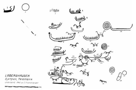
A common motif in the Bronze Age carvings in Gjerpen and south in Østfold and in Bohuslän in Sweden is ships with small lines that have been interpreted as people. This may indicate that there was a common Bronze Age culture across the outer Oslofjord that had contact with each other by ships across the fjord and that the first farmers came to Gjerpen from the south and east.
A typical feature of the landscape in Gjerpendalen is the longitudinal north-south ridge. This meant that the waterways from the inland that came in from the west met this mountain ridge so that the river formed a right angle and flowed south.
The broad ridge that has forced the river south has therefore protected the area eastwards from leaching of the salt that binds the clay. Unlike other important agricultural areas in Norway such as Østfold, Romerike and not least Trøndelag, Gjerpendalen does not have quick clay.
Large parts of the broad ridge have also been under the sea and the bottom mud has provided good agricultural conditions. The most important large farms and centers of power have therefore been established along this ridge.

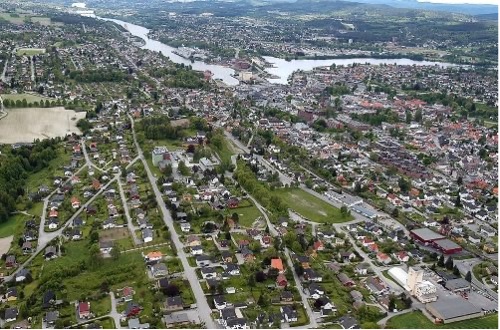
Skien seen from the west shows how the waterway that comes into the city from Øvre Telemark meets the mountain ridge that separates the inland waterway from what was originally a long fjord arm, but which has now become the Skienselva River that flows out to the left.
In the foreground of the picture, the remains of the green, fertile fields of Bratsberg can still be seen. On the small wooded knoll at the bottom right is the ruin of the church on Kapittelberget.
In front of the large mountain ridge is a smaller mountain ridge that has been pierced by four waterfalls that have divided this ridge into four islands, the largest and most important of which is Gimsøy, which is located farthest to the left in the picture with the large, white factory building of Union.
The sound of the waterfalls is one of Henrik Ibsen's most important memories of Skien. Throughout the day, he remembers, the air was filled with "the muffled roaring rush of Langfos and Klosterfossen and the many other falling waters."
He also wrote as late as 1895 to Hildur Andersen:
You should have seen more of the ski and heard more of it too. For Skien, they are a city of stormy, rushing and seething waters. All over the city there is a song in the air from all the waterfalls. At least that's how it stands in my memory.
– and then he adds:
It is not for nothing that I was born in the city of waterfalls.
The picture above clearly shows the long lines in the landscape. In the foreground is Lagmannshøgda with the former county hall for Telemark. This is where Lagmannsgården or Gjerpen Lille was located. Further south, the trees surrounding the manor houses at Søndre and Nordre Brekke are clearly visible. In the background on the left are Kapittelberget and Bratsberg and furthest out is Borgestad.
On the shore of the quiet cove at the very end of Bryggevannet, at the transition between the inland waterway and the waterway out to the coast, a small craft and trading center with simple wicker huts grew up more than 1,000 years ago.
It was based on tanning reindeer hides and processing reindeer antlers from the Hardangervidda plateau and whetstones from Eidsborg and Lårdal. It shows how extensive the inland area was that created Skien and about the importance and extent of the waterways both inland in Telemark, but also outward from Skien. Whetstones from Skien have been found again across large parts of Northern Europe. It shows the extent of the trade connections that would become the basis for the city of Skien.
Today's Trade Square is the last remnants of this original Skien. There were older trading places than Skien in Northern Europe, such as Skiringssal in Vestfold, Birka in Sweden and Hedeby in Denmark, but while the others have disappeared, only Ribe in Denmark and Skien still exist as cities today. The Trade Square in Skien represents more than 1000 years of trade and crafts and an extensive network both inland in Telemark and beyond in Europe.
And it was precisely here, in Stockmann's farm by the square, that Henrik Ibsen was born on March 20, 1828. He was therefore not born in Skien by chance, but he was actually born in the heart of what had been Skien and the prerequisite for Skien for more than 1,000 years before he was born.

Aerial photo from Hoppestad north in Gjerpendalen and southwards. Far out on the horizon in the middle of the picture it is possible to glimpse the Frierfjord, but it is still a long way from there to the coast. So Skien is neither a coastal town nor has it ever been a coastal town. The picture clearly shows the long lines in the landscape and the elongated mountain ridges. On the widest ridge to the left were the farms Limi and Grini and further south Rising and Gjerpen. Then came Lagmannshøgda, Bratsberg and furthest out Borgestad. On the middle ridge, in the middle of the picture, were the Venstøp farms in a row. To the right in the forest grove where the river makes a bend, lies Fossum. At the very bottom of the picture at the crossroads by the river and the railway, Luksefjellveien, the former royal road to Kongsberg, begins.
All of Ibsen's ancestors and foremothers have come to Skien from outside, from the coast, from other cities in Norway, from Denmark, Germany and the Netherlands and have played important roles in the development of Skien. Some have established themselves as civil servants in Skien or married civil servants and administrators in Øvre Telemark. Some of them have then returned to Skien and become skippers and merchants in the seafaring city of Skien. Some have also come to Skien by land from Kongsberg or have taken the detour via Kragerø and other places along the coast.
The reason why Ibsen's ancestors and foremothers have come to Skien over several generations has been that the area where Skien grew as a city has been an important center of power and trade in Norway.